Historical Society Eticup
PLAQUE UNVEILED AT ETICUP
Historical Society Commemorates Foundation of Church
Great Southern Herald
25 June 1954 – P1
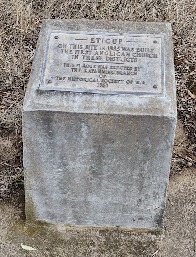
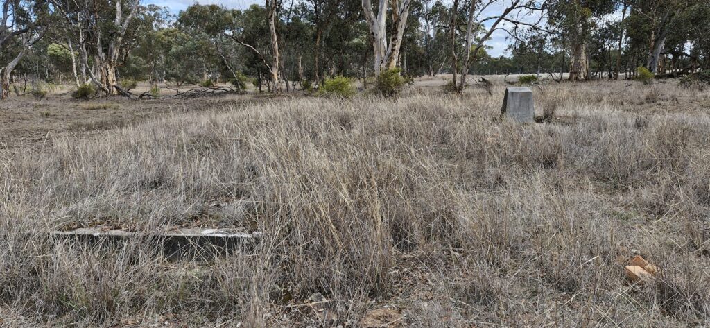
Two descendants of early settlers in the Eticup district on Saturday, June 12, 1954, unveiled a plaque on a cairn which indicates the spot where the first Anglican Church had been built in the district. They were Mr Horace Tylor, member of the Katanning branch of the Royal Historical Society of W.A. (History West), and six-year-old Tony Nelson, a fifth generation descendant of the Nelson family.

The plaque bears the inscription:
— ETICUP —
On this site in 1885 was built
the first Anglican Church in
these districts
This plague was erected by
The Katanning Branch of
The Historical Society of W.A.
June 1954

The unveiling ceremony was held during a tour of the Broomehill district by 30 members and friends of the Katanning Branch of the Historical Society of W.A. When the party arrived at the spot where a cairn indicates the Eticup Church had been built in 1885, the president of the Katanning branch, Mr C. R. Garstone, said the erection of the cairn was an indication the Society was fulfilling its duty by marking historical sites. He expressed thanks for the excellent work which had been done, gratuitously, by Messrs A. Burridge and Bain, and then called on Mr J. F. Hillman to speak on the history of the district.
Mr Hillman said the church, which had now been demolished, had been consecrated by Bishop Parry in 1885. It was used both as Church and school until 1892 when, owing to the building of the Great Southern Railway, the decline of Eticup begun.
After the unveiling ceremony by Mr Tylor and Tony Nelson, the party, under the guidance of Mr Norman Beeck, then visited several places of historical interest, including the original home of Thomas Norris and the old Eticup cemetery.
Proceeding to Langwell, or as it is now known “Shiloh College“, the party had tea followed by the usual bi-monthly meeting at which the reading of the monograph “The life of William Henry Graham” was concluded.
After the meeting the party was entertained by Mr Tinsley Beeck who showed films of the Queen’s arrival in Sydney; the life of Albert Namatjira, the aboriginal artist, and a beautiful picture of underwater marine life. Mr Garstone then expressed sincere appreciation to everyone whose efforts had made the tour such an outstanding success.
On the way to Eticup the party stopped at Fairfield, the home of Mr and Mrs L. Lucas, who showed the party over the old home, which was built by William Henry Graham in 1865. Many interesting features of the two storied house and the outbuildings were noted and discussed.
Quite a few years ago Shirley MacDonald began to work through the diaries of her grandfather, Thomas Norrish, which he wrote when he first came to Eticup to take up farming, and the diaries of William Henry Graham who was also one of the first pioneers of the Eticup district.
Shirley collated all the information both in alphabetical and chronological order. There are many wonderful pieces of information and anecdotes in these diaries, and we are proud to share them with the community each month.
LAMB
Lamb worked for George Norrish at Oak Farm. On 1st November 1890, young Lamb called at Goblup, and on 16th March 1893, young Lamb brought back the two rams that Thomas Norrish’s brother George had.
LAND GRANTS AND LEASES
A chart printed in the early 1860s shows that most of the land near Ettakup Pool, and in a broad band west to Kojonup, had been taken up in pastoral leases. Thomas Norrish had 4,000 acres at the Pool including three freehold blocks totalling 42 acres; Edward Spencer had 45,000 acres incorporating Locations 12, 26 and 38, totalling 125 acres: Edward Treasure had 28,000 acres at Woodarabup and Martinup with a small freehold block at the latter location: William Henry Graham had 10,000 acres with a 40-acre homestead block at Nanamillup. A Moir’s 10,000 acres adjoining Treasure’s leases encircled Solomon Drolf’s Location 36 at Mullidup. This lease would have been one of Drolf’s that passed to Moir in 1864. Drolf’s other leases totalling 12,100 acres are not shown on this chart.
Another chart printed later shows that by the 1870s, Thomas Norrish had more leases; Edward Spencer’s leases had been divided between Lady Campbell and Joseph Spencer; Patrick Garrity had over 9, 000 acres in the immediate vicinity; and Edward Treasure had taken up a considerable area closer to Ettakup. In addition, Lady Campbell had been granted 2 x 100 acre freehold blocks at Goblup; Graham had added 100 acres next to his homestead block; Patrick Garrity had 142 acres at Coolearup (Green Hill); and one immigrant Grant and several Special Occupation leases had been issued between Ettakup and Goblup. Other charts in the area cover areas further afield and show some of John Holland’s land. Photocopies of various chart sections are held in the Eticup folio in the Museum.
As far as freehold land is concerned; it is thought that earlier grants were by direct purchase from the Crown. Edward Spencer paid £10 for Location 12 (10 acres) and Solomon Drolf paid £12 for Location 24 (12 acres). Lady Campbell’s 100 at Goblup cost her £62.5.0.
Land regulations of 1873, provided for the issue of Special Occupation Leases (SOL) that enabled the less affluent to acquire land. The lessee was required to carry out improvements to the land within a set period (two years) and obtain a certificate to that effect. Improvements were then registered with the Survey Office in Perth and a formal application submitted for grant of the land freehold. Finally, the Government (eventually) issued Deeds of Grant and Title. Thomas Norrish purchased Location 206 where Sunnyside is built under this scheme, but the block had previously been granted to an ex-policeman named Kennedy (Immigrant Grant 21).
On 15th May 1883, Thomas Norrish wrote in his diary, “Went to Mr Van Zuilecom this evening to get from him a certificate stating that there are no improvements on the 100 acres that did belong to Kennedy.” The house was started soon afterwards and constituted improvement to the block. All transactions regarding land grants, including the issue of withdrawal of SOLs and the declaration of town sites, were promulgated in the Government Gazette. Norrish subscribed to this publication to keep abreast of affairs.
William Henry Graham was frequently called upon to measure other settler’s selections for them. As well as a chain (which others no doubt had) he had a circumferentor (an instrument fitted with a compass) which ensured accuracy of angles, but there is some evidence that in the early days the land was usually remeasured by an Assistant Surveyor. In later years, much of the survey work was done by H.S. Ranford.
A chain was a 20.1 metre length of 100 metal links, with different symbols placed periodically to indicate the progressive number of links. Note: 80 chains = 1 mile = 1.61 km. 1 acre = 0.405 hectares
Historical Society Eticup
